Media Player Features
Map-Powered Video
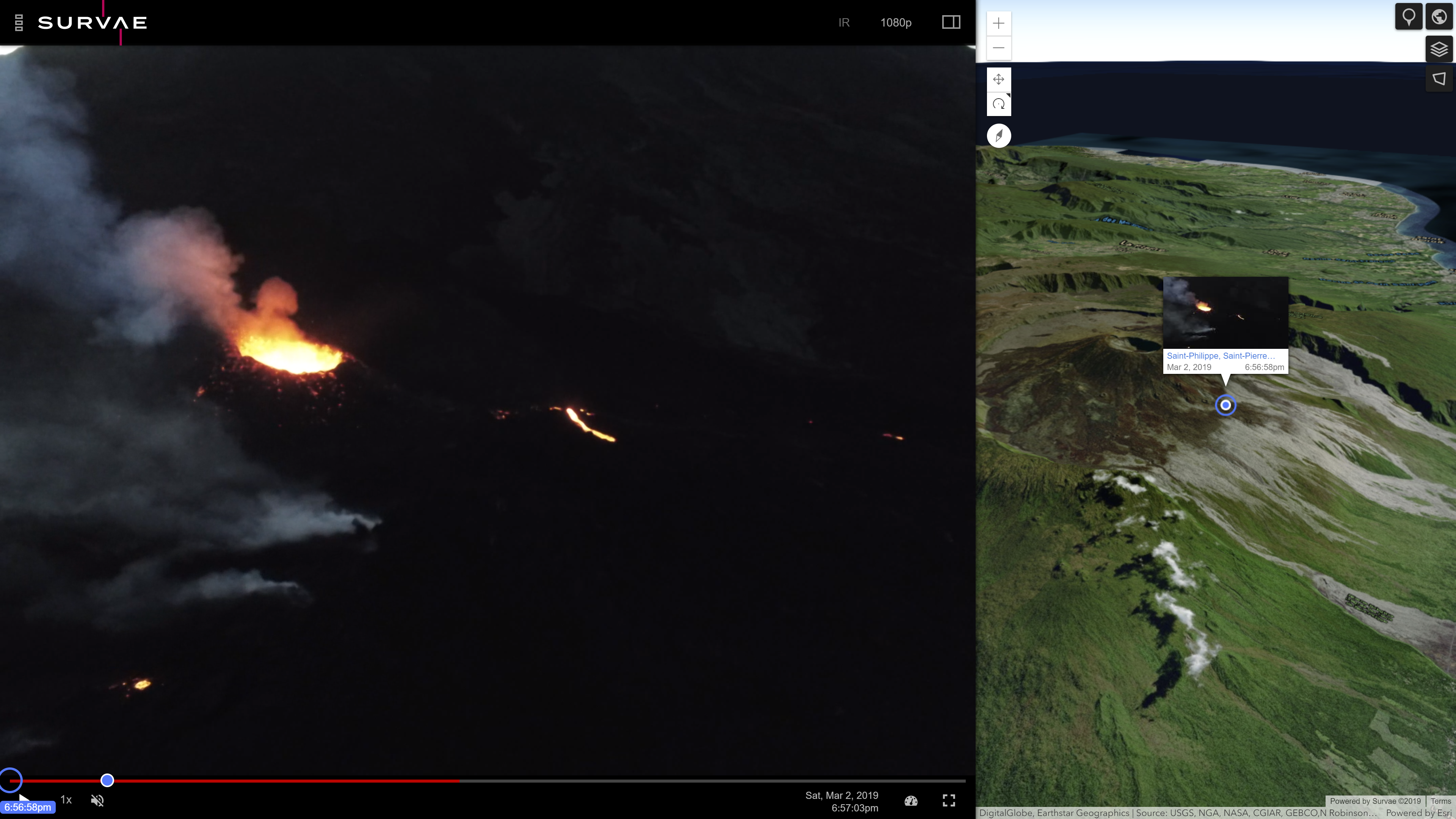
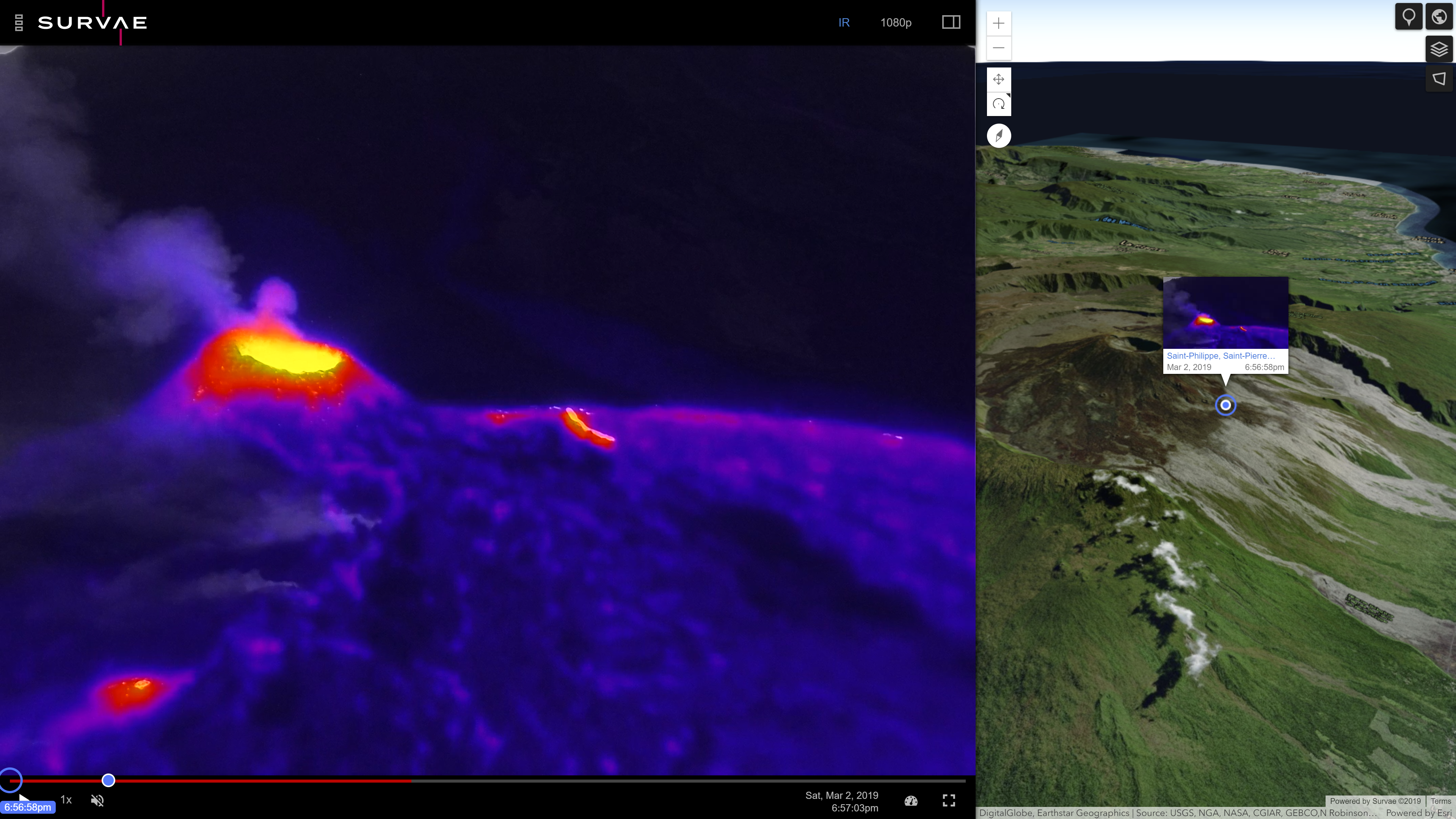
The Survae media player includes a map, displaying the location or route captured by the camera. Hover for thumbnail preview and click to go there. A blue dot shows your current location.
Images and Image Sequences
View images and image sequences in context to time, location, and each other. High resolution still images, captured over long distances, are linked and displayed as a single result. Image sequences can be hover-previewed, played, and easily shared.
360° Panoramas & Video
View 360° panoramas captured by Parrot ANAFI, DJI Mavic 2 Pro, GoPro Max, Insta360 ONE X (with GPS remote), Google’s Street View mobile app, and other GPS-enabled 360 cameras. Video from the Garmin VIRB 360 camera is also supported.
Thermal Imagery
Toggle between visible and thermal video streams, captured by supported devices.
Media and Data Management
Powerful and Intuitive Search
Easily find content captured of places and events, by time and location. Search results are displayed on the left panel, on the search map, and along the timeline, with each offering unified hover preview. The map and timeline can each be used to narrow down results to only what is within view.
world.survae.com
Survae’s interactive, map-based interface and visual search engine provide an ideal solution for managing, working with and making sense of the massive amount of visual, sensor and third-party data being collected by UAVs, ground-based and underwater devices.
Visual Search
Survae provides powerful geospatial search capabilities to find events, places, and objects from multiple viewpoints — filterable by date, time and viewpoint, using Esri or Google maps and public or private data.
- Intuitively find and visualize place and event video, imagery, and related data.
- Use visual search to find anything.
- Mouse over any location to see all of your assets associated with that location.
- Use filters to zoom in on the exact view you are looking for
Text, Map & Timeline Search
Use relational, spatial and temporal methods to drill down to find content.
Run searches and queries of data using locations, date, time and tags.
Search using sensor and third-party data sets.
See all of your video and image assets on a central map and find imagery using the map itself.
Event Analysis and Visualization
Identify and visualize relationships between incoming imagery, sensor data and virtually any other data source.
Wide Device Support
Drones / UAVs
Survae currently supports DJI, Parrot Anafi and Anafi Thermal, and Yuneec H520 UAVs. Contact us for other UAV product integrations.
GPS-Enabled Cameras
Survae supports Garmin, GoPro, and other GPS-enabled cameras. These cameras can be mounted to just about any platform, providing geolocated video and imagery from air, land, and sea.
MISB Compliant
Survae supports live and recorded video captured by sophisticated MISB-compliant cameras. Often found mounted to airplanes and helicopters, larger UAVs, vessels, and law enforcement and military vehicles, these cameras embed data into captured video.
Integrations
Data APIs
Ask us about building support for your application. Data may be used to enhance searches, add geospatial context, or linked to video, imagery, and other data, along a timeline.
Platforms & Applications
Leverage Survae to add live or recorded geolocated video and online or offline data management to your existing platform or application. Whether embedding our video player within an existing application or tying multiple platforms together, we offer a unified and contextual view of places and events.
Custom Solutions
Our intuitive interfaces add rich context for fire, police, city management, transportation, energy, communications, insurance, and other infrastructure platforms. Ask us about fusing video from manned and unmanned aircraft, dash cameras, CCTV networks, sensors, and other intelligence into a unified and multifaceted view into places and events.
Platform Architecture
Cloud, Local Server, and Single Device Solutions
We offer flexible solutions for your organization’s complex needs. The Survae Cloud includes an easy way to manage and share content. Edge servers are an option for global accounts as well as country-specific server locations to meet EU privacy laws. Local server and single-device installations offer online and offline capability, in-house data management, optional cloud-sync, and still provide the power of Survae’s map-enabled search and video playback.
Access, Sharing and Collaboration
The Survae platform was built for managing, working with and sharing content in a single office or across multiple offices, agencies, groups, locations or organizations. Share mapped videos internally or externally with links or embed on any website with Survae’s HTML5 player/map.
Open Framework
The Survae platform was built to work with other technology solutions and platforms. Integrations of third-party or client data services and APIs, custom applications, and feature service layers for client applications are available. Please contact us if you would like to add Survae’s video, image, and data capabilities into your existing solution.