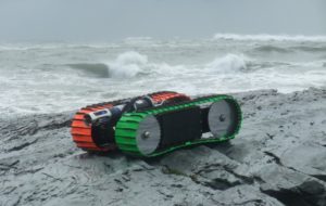
Sea Otter, the world’s first tether-less amphibious robotic crawler, is now integrated with Survae, providing a complete solution for capturing and displaying video and sensor data connected to maps
 SURVAE, the geospatial media company based in Wilmington, NC, and C-2i Innovation, the developer of autonomous amphibious robots, located in Stow, MA, today announced that SURVAE’s digital asset management platform is now connected to C-2i’s Sea Otter for all-weather inspection, sampling and mapping of shore and water regions, from oceans and harbors to rivers, estuaries, marshes and tailing ponds.
Portable and deployable from beaches and small boats, the Sea Otter provides persistent sensing where unmanned underwater vehicles (UUVs) and remotely operated, tethered underwater vehicles (ROVs) cannot. Operating up to 10 miles from shore, the Sea Otter is highly maneuverable and able to cover multiple stations with a single deployment, providing versatile station keeping for up to 5 months in all weather/all season situations. Designed for sensing, sampling, station keeping, mapping, search and rescue, and military uses, the Sea Otter operates autonomously or with real-time remote control. High sea-state capability and shore-side self-deployment and recovery open the window for persistent, long duration high fidelity sampling, mapping and inspection.
“SURVAE is excited to partner with C-2i to enable an end-to-end solution for visualizing and mapping the imagery and sensor data collected by C-2i’s innovative autonomous devices,” said Eric Hesterman, CEO of SURVAE.
Imagery and sensor data captured with the Sea Otter is easily imported into the SURVAE platform. Video and images are automatically connected to the map, showing the recorded route and location of the Sea Otter at all times. Every frame of imagery is geolocated, date and time stamped. Sensor data collected by the Sea Otter is automatically visualized and connected to associated imagery, maps and a timeline. SURVAE’s powerful geospatial search capabilities enable Sea Otter clients to easily find events, places, and objects in their archived data, filterable by location, date, time, tags, viewpoint, using their own maps.
“The long range and duration of the Sea Otter and the ability to carry any number of sensors resulted in a unexpected quandary. The mass of resulting data from disparate formats—from imagery to hard data—made analysis tedious and confusing,” said Arnis Mangolds, Presdent of C-2i. “The SURVAE solution simplifies tracking where the data came from and simplifies interpretation in such an understandable fashion that nontechnical personnel can now create their own hypothesis. The combination of the Sea Otter capabilities and SURVAE’s data presentation will enhance research and public acceptance by leaps and bounds.”
###
About C-2i: C-2 Innovations Inc. develops autonomous, amphibious robots for the estuarine environment. Often ignored due to the difficulty and danger of transit, C-2i’s Otter family opens up new areas of sampling, measurement and observation. Being traction-based, living in the boundary layer, and non-concerned with weight, shape or volume, the Sea Otter goes beyond bathymetry, enabling direct measurement with sensors of convenience. The system can transit very low bearing pressure soils that can not support human traffic, operate in high currents such as the surf or in rivers, and can remain on station without power, opening up a whole new world of scientific discovery.
The sample video above shows the integration of C-2i’s Sea Otter with the SURVAE platform. Sensor data collected by the Sea Otter is connected to the video and the map. Mouse over the data to see the corresponding video at any point. Mouse over the map to see the imagery and data from any location and to play the video from any location on the map.